

Here are 3 Places You Can Always Go
Wikipedia Creative Commons‘ CC BY-SA
Listen!
Drottninggatan (Queen Street) in Stockholm, Sweden,
is a major pedestrian street. It stretches north from the bridge Riksbron at Norrström, in the district of Norrmalm, to Observatorielunden in the district of Vasastaden.
Forming a parallel street to Vasagatan and Sveavägen, Drottninggatan is intersected by (south to north) Fredsgatan, Jakobsgatan, Herkulesgatan, Vattugatan, Klarabergsgatan, Mäster Samuelsgatan, Bryggargatan, Gamla Brogatan, Kungsgatan, Apelbergsgatan, Olof Palmes Gata, Barnhusgatan, Adolf Fredriks Kyrkogata, Wallingatan, Kammakargatan, Tegnérgatan, Rådmansgatan, Kungstensgatan and Observatoriegatan.
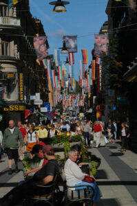
The major part of the street is car-free and lined with numerous stores and shops, one of the largest being the Åhléns City department store. During summer, the street is often crowded with tourists.
The street was laid out in the 1630s and 1640s when the surrounding area was built on a rectilinear grid plan, a significant innovation in Stockholm’s urban environment. It was originally named Stora Konungsgatan (“Great King’s Street”) and was later renamed as Drottninggatan in honour of Queen Christina, who ruled from 1632 to 1654. Its name was paired with that of nearby Regeringsgatan (“Government Street”). This style of naming was relatively novel for Scandinavia, which did not have a tradition of streets named for the king or queen. It was most likely borrowed from Amsterdam or Copenhagen, where groups of streets were given names from the same semantic categories. Thus in Copenhagen’s district of Christianshavn, laid out in 1618, three streets were named Kongens gade (“King’s Street”), Dronninggaden (“Queen’s Street”) and Prinsensgade (“Prince’s Street”).
Copenhagen’s largest shopping area is centered around Strøget in the heart of the city.
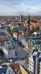
Strøget is one of Europe’s longest pedestrian streets with a wealth of shops, from budget-friendly chains to some of the world’s most expensive brands. The stretch is 1.1 kilometers long and runs from City Hall Square (Rådhuspladsen) to Kongens Nytorv.
Strøget is a nickname from the 1800s and covers the streets Frederiksberggade, Nygade, Vimmelskaftet and Østergade and Nytorv square, Gammeltorv Square and Amagertorv Square.
Strøget is most famous for shopping. Big international brands like Prada, Max Mara, Louis Vuitton, Mulberry, Hermès and Boss are represented at the end of the street facing up to Kongens Nytorv.
If your budget is more limited, you can continue along Strøget down towards City Hall Square, where you find shops like H&M, Vero Moda, Weekday and Zara.
However, Strøget is not just shopping. Look up and down the side streets during your shopping spree, and you will see several of Copenhagen’s beautiful sights and attractions, such as Helligåndskirken, Church of Our Lady (Vor Frue Kirke), where Crown Prince Frederik and Crown Princess Mary were married, behind Gammeltorv Square, the court house at Nytorv Square and the Stork Fountain (Storkespringvandet) at Amagertorv Square.
From Amagertorv you can also see across the canal to Christiansborg Palace, where the parliament sits. And do not forget City Hall Square (Rådhuspladsen) with Copenhagen City Hall Tower and the beautiful Kongens Nytorv square with The Royal Danish Theatre and Nyhavn in the other end of Strøget.
Strøget is a popular hangout for the city’s street performers. Especially at Amagertorv Square you can often see performances by acrobats, magicians and musicians.
Karl Johans gate is Oslo’s main boulevard,
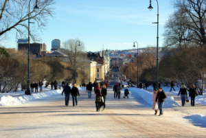
leading from the Central Station through the central shopping district and up to the Royal Palace. Snøhetta re-designed the historic streetscape to create more engaging public and green spaces for pedestrians, and improve stormwater management and the streetscape’s pavement.
The designers focused on enhancing the dramatic perspective of the new Karl Johans gate by reinforcing the strong middle axis. The pavement on the south side was re-finished to create a symmetrical street profile. During the day, the curbs and shadow further enforce this perspective. All vertical elements placed on the pavement, like light- and flagpoles, are also defined by these lines. At nigt, the perspective is highlighted through the rhythm of the streetlight poles.
More than 50 custom-made details and elements have been designed for this project. The large scale of the details reflects the importance of this project. The rainwater runoff from the Parliament and the Palace meet at the lowest point on Karl Johans gate, and is then transported by drain elements designed as infrastructural sculptures which lead the water to the underground river ‘Bislettbekken’.*
*Bislettbekken was a stream in Aker and Oslo . It left the area north of the current Ullevål hospital and ended approximately at Rådhusplassen . Most of the stream today is in pipes.