Almost 300 years ago, many of our District 3 Zone Directors would have used the oldest road in America to visit their lodges.
 Not many people realize the oldest road in America was created to connect Charleston and Boston by way of a 1,300-mile simple roadway closely following the coast in the American colonies. It was laid out and constructed between 1650 and 1735 and parts of it still exist today, at least in South Carolina. Other sections, particularly on the more northern end, have been incorporated into major highways.
The King’s Highway was a roughly 1,300-mile (2,100 km) road laid out from 1650 to 1735 in the American colonies. It was built on the order of Charles II of England, who directed his colonial governors to link Charleston, South Carolina, and Boston, Massachusetts.
In time of war it was used to move militia, supplies, and British soldiers from one colony to another. The intercolonial road originated as a series of Native American trails, which were joined together and gradually enlarged to support animal, wagon, and stagecoach traffic. The segments were built at different times by the individual colonies during the seventeenth and eighteenth centuries. Even at its best, the condition of the route was seldom good. Narrow roads, ruts, mud, obstructions, and poorly maintained bridges and ferries were just a few of the inconveniences to be expected. The section between Wilmington and Charleston was judged by some travelers to be “the most tedious and disagreeable of any on the Continent.”
The entire length of The King’s Highway did not become a continuous wagon road until about 1735. Incorporating the Boston Post Road (opened in 1673), the route traveled over 1,300 miles, from Boston, Massachusetts to Charles Town, South Carolina. Along the route, there are numerous communities today with a King Street, King’s Road, or King Avenue, all remaining from the days when it was called the King’s Highway.
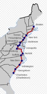
Boston to New York: The King’s Highway followed the same route as the Boston Post Road, or today’s Interstate 95.
New York to Philadelphia: The route crossed the Hudson River by ferry from Manhattan Island to Newark, New Jersey, from there much the same as the present-day New Jersey Turnpike to Trenton. It ferried the Delaware River at that point and followed what is now Interstate 95 into Philadelphia.
Philadelphia to Alexandria: this portion of the King’s Highway was also called the Great Coastal Road, and followed the same path that US Highway 40 takes today.
Alexandria to Norfolk: This portion of the King’s Highway was often called the Potomac Trail. It followed the same route as US Highway 1 from Alexandria to Fredricksburg, then VA Highway 2 through Bowling Green, then southeast on VA Highway 721. The old route crossed the Mattaponi River into King William County, then the Pamunkey River into New Kent County, then on to Williamsburg, Yorktown, and Hampton, where a ferry crossing landed at Norfolk, Virginia. Although an important route during the American Revolutionary War, the use of the road lessened significantly after the capital of Virginia was moved from Williamsburg to Richmond in 1779.
Norfolk to Charleston. Leaving Norfolk, a traveler on the King’s Highway began a difficult trek through and around the lowland swamps of the tidewater areas of Virginia and the Carolinas. Many fords were necessary on this route, which followed present-day US Highway 58 from Norfolk to Suffolk, Virginia; then into North Carolina via what is now NC Highway 32; skirting west to avoid the Dismal Swamp and then south to Edenton, North Carolina.
From the Quaker communities around Edenton, the old highway followed what is now US Highway 17 to New Bern, North Carolina, an important seaport and the early colonial capital of North Carolina. From New Bern, the highway bypassed White Oak and Angola Swamps in a fairly direct line to Wilmington, North Carolina at the Cape Fear River. As US Highway 17 does today, the old road continued on to Georgetown, and finally to Charles Town, the colonial capital of South Carolina, and the southern terminus of the King’s Highway.
The South Carolina section of the King’s Highway, built between 1739 and 1750, crossed the North Carolina line just above Little River on its way to Georgetown. It then skirted the Santee delta before passing through Jerveyville (McClellanville) to reach Charleston. The route to Savannah likewise followed the higher ground away from the coast in order to avoid the Edisto, Combahee, and Broad River basins and did not pass an important settlement until it stopped at Purrysburg on the Savannah River. While individuals could travel on foot or by horse, wagon, or carriage, the easiest and most economical mode was by post stagecoach. The driver was responsible for repairs and for fresh horses, accommodations, and food, usually to be found at inns every seven to ten miles along the way. In the twentieth century much of this road became utilized as U.S. Highway 17.
Later, the road would be extended North to Maine.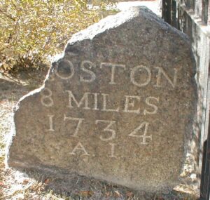
In 1761, then-Postmaster General Benjamin Franklin ordered milestones placed along the 1673-established route from Boston to Saco, Maine, initially, then all the way to Machias, as a northern extension of King’s Highway.
As part of his duties, Franklin conducted inspections of the roads that were used for delivering mail. One method of charging for mail service was by mileage, so Franklin invented an odometer to measure mileage more accurately. The King’s Highway, as a result, morphed into the Post Road.in this part of the colonies.